

Maritime Spice Routes¹ was the epicenter of the global economic power. Geographically, the routes stretched from Nusantara Archipelago to Europe, the Middle East, Africa, and East Asia (China). The Maritime Spice Routes existed long before the Chinese "Maritime Silk Roads". The Maritime Silk Roads stretched from the ports of China, South China Sea, Strait of Malacca, Sunda Strait, Lombok Strait, and then headed toward the Persian Gulf, Red Sea, and the Gulf of Aden to Europe, traversing the Indian Ocean. The routes widened the range until they reached Asia, East Africa, West Asia, and Europe (Luhulima, 2014). And then, a critical question emerged: Is it possible that Indonesia benefited from the massive development of the Maritime Silk Roads that directly intersected with the Maritime Spice Routes?
Geopolitics and Geoeconomics
In terms of geopolitics and geoeconomics, the existence of the Maritime Spice Routes and Maritime Silk Roads are intersected and integrated. Geographically, the Maritime Spice Routes cover almost all the Southeast Asia waters. Current Southeast Asia waters territory was included in the inter-insular and international sailing and trade routes in the past. As the global economic power, China which carries the Maritime Silk Roads must collaborate with Southeast Asian countries, especially Indonesia. Because, as the sea route, the Maritime Silk Roads is in the Indonesian Archipelago waters. The waters cover the Strait of Malacca, Sundanese Strait, Lombok Strait, part of South China Sea to the Indian Ocean.
There is, indeed, a maritime boundary in the South China Sea. Indonesia has assigned the waters in the South China Sea border as the North Natuna Sea waters. Based on the international law of the sea, China cannot claim its maritime boundary with Indonesia to the North Natuna Sea. Because according to the international law of the sea (United Nations Convention of Law of the Sea/UNCLOS) 1982, China is not an archipelagic state. Therefore, China cannot draw its maritime boundary from the outer island or to the North Natuna Sea.
Practically, the declaration of the idea of China's "Maritime Silk Road" of the 21 century has preceded the concept of Indonesia's World Maritime Axis. Indonesia just declared the World Maritime Axis through the Asia-Pacific Economic Cooperation (APEC) and East Asia Summit IX forums, November 2014. However, Indonesia cannot stand idle in facing China's aggressiveness through its Maritime Silk Roads. One that deserves attention in terms of geopolitics is China's gesture to persuade Thailand for more than a decade. China has been trying to collaborate with Thailand concerning the Kra Canal opening project. The canal will connect the South China Sea with the Strait of Malacca and the Indian Ocean. The canal opening will change the shipping arrangement of Southeast Asia. Later, the maritime supply chain of both goods and services from and to China will be shorter. It will impact the increase of efficiency and effectiveness of the goods and service movement that enter the ports in China's coastal area and along the Maritime Silk Roads. According to us, sooner or later, it will be realized. Furthermore, China is currently one of the global economic giants along with the United States of America.
A question emerged as a response to the analysis above, "Will the Strait of Malacca, Lombok Strait, and Sundanese Strait die as the sailing and trade routes with the opening of the Kra Canal in the future?" The answer is supposed to be no. Because the sailing route to the Pacific from Australia traversing the Indian Ocean, entering Lombok Strait, Ombai-Wetar, Makassar Strait to the Banda Sea will thrive along with the implementation of the World Maritime Axis concept. It is proven that in the APEC forum, the member countries welcomed President Jokowi's offer about the World Maritime Axis last 2014. Meaning that the APEC member countries like the US, Japan, China also have the same interest in terms of geopolitics and geoeconomics.
How does Indonesia implement the idea of the World Maritime Axis to be parallel with China's Maritime Silk Roads? In the East Asia Summit IX Forum in Myanmar, President Jokowi stated five pillars of the World Maritime Axis a la Indonesia: (i) establishing maritime culture; (ii) maintaining and managing sea sources based on the fishing industry and fishers (iii) building infrastructure and maritime connectivity; (iv) developing maritime diplomacy and marine partnership cooperation; and (v) strengthening ocean-based maritime-defense. In our view, the maritime axis pillars should not stop there. Until this second period, President Joko Widodo's government is supposed to keep transforming the trade power and maritime greatness in the past to complete the World Maritime Axis.
The Maritime Economy Pillars of the Past
Historically, the Nusantara maritime economy's greatness pillars of the past focused on three things: (i) trade between regions, inter-insular and international, (ii) sailing, and (iii) seaport-base coastal city. Why? History recorded that the European nations were ambitious in exploring oceans to dominate trade and get spice commodities in Nusantara. The reason behind it was since Mesopotamia, Ancient Egypt, Roman, Persian, Chinese to Indian civilizations, the native spices typical of Nusantara became the world's prima donna.
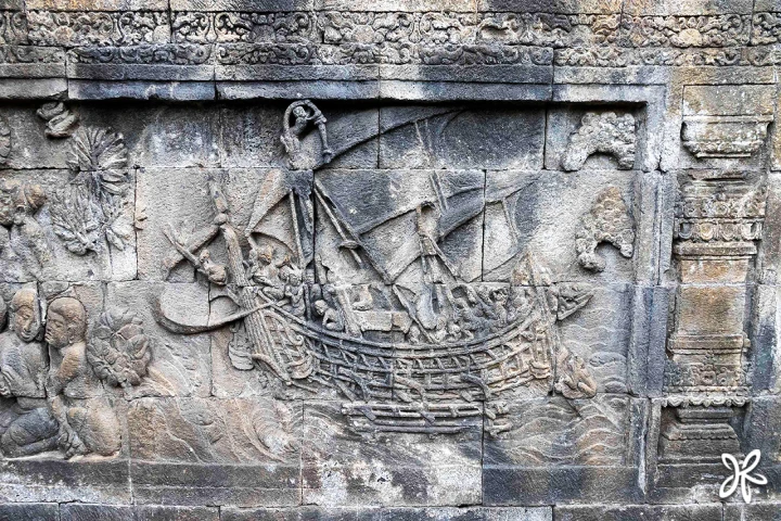
Further, a document from the Ptolemaic Egyptian Dynasty, kept in the Alexandria Library, identifies the world maritime's greatness existed on the west coast of Sumatra. The document remarked the name Barosai land and Karpura Dwipa or Minanga Kambawa, the camphor and pepper supplier in Egypt. The historian PH Brans interpreted the term "Barosai"–which was written in his dissertation–as Barus. He also explained that when the camphor and pepper supplies stopped, the Egyptians sailed to the source country, followed by the royal dignitaries. Some of them stayed in Nusantara. The information indicated how important sea transportation was as Nusantara maritime economic power in the world spice trade.
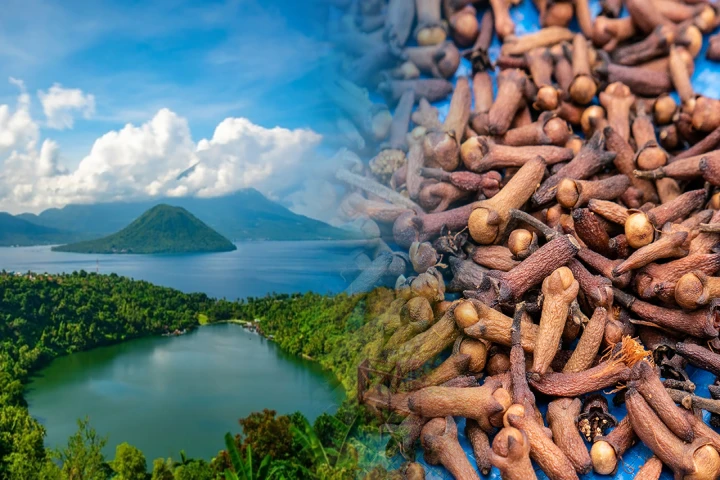
Another historical fact sourced from Anthony Reid. He noted that along the 15th to 17th centuries, Nusantara's economic greatness period was due to the spice trade (nutmeg, clove, pepper), wood (agarwood, sandalwood), camphor, and coffee. The peak of the spice economic golden period occurred in the era of the coastal Islamic kingdom's glorious era accompanied by the development of coastal cities in Nusantara. In the coastal city, ports and markets were developed. Some of the ports that still function today are Pottere Harbour in Makassar, Lembar Port in West Nusa Tenggara, Port and city of Sibolga on the west coast of Sumatra, Teluk Bayur Port and the city of Padang in West Sumatra, the port and city of Ternate, Murhum Port and the city of Bau-Bau in Southeast Sulawesi, the port and town of Gresik in East Java, the port of Banten and city of Serang in Banten Province, to the port and city of Cirebon. Ports and coastal cities became the silent witness of the maritime economic glory in Nusantara that lasted until near the 17th century.
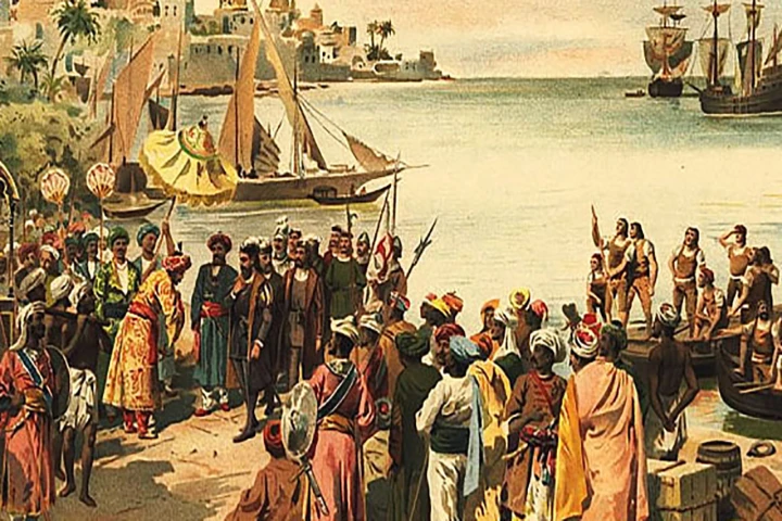
The French, British, Portuguese, and Dutch just arrived in Nusantara after the 17th century. The Dutch became the longest to entrench in Nusantara. Besides establishing the Dutch East Indies colony, the Dutch, with an organization Vereenigde Oostindische Compagnie (VOC) established on 20 March 1602, also controlled the spice trade in Nusantara. History recorded that VOC strictly enforced the spice trade prohibition in Nusantara through the Hongi exploration surveillance in the Maluku Islands in the 17th to 19th centuries. The purpose is to monopolize the Nusantara spice commodity trade.
The Maritime Spice Routes
The rise of the spice-based maritime economy gave rise to the term Maritime Spice Routes. It also inspired us to spawn an idea in a writing entitled Political Economy Revitalization of the Maritime Spice Routes. The idea is undoubtedly exactly the same as China's inspiration that gave rise to the "Maritime Silk Roads". The Silk Roads in China are the trade routes of Asia, the Middle East, Europe to Africa in the past, traversing the land of Asia to Europe. We believe that the inspiration of the World Maritime Axis initiated by the Indonesian government in 2014 through the "maritime toll" concept refers to the Spice Routes. The difference between World Maritime Axis and Maritime Spice Routes is that the Maritime Spice Routes adds three maritime economic power base pillars.
There is a problem and setting of political economy in the contemporary era. If the maritime, political economy prima donna that attracted the Europeans competing to reach Nusantara were spices in the past, today, what commodity can be a prima donna in terms of political economy? The government needs to identify the type of commodity that supports the glory of contemporary Maritime Spice Routes.
Next, we see that the idea of the World Maritime Axis is supposed to be integrated with Maritime Spice Routes. The integration will revitalize at least three things. First, the government must revive the people's sailing among countries or inter-insular in Indonesia, especially the east part. The problem is, today, our people's ship industry seems to be in a near-death state. It's tough for the people's ship industry to get financial support. Furthermore, in a current national economic situation with the Covid-19 pandemic. The question is, does the government have the political will and bravery to make a policy that can support the people's ship industrial capital through the banking credit scheme? Is it possible that the government issues an affirmative policy from the monetary side in the form of low-interest financing for the people's ship industry? The government should dare to issue the policy. Furthermore, the people's ship industry's raw material in the form of wood is becoming more expensive and hard to find. It is due to the population of Indonesian forests, which provide the type of wood as the raw material to build the ships, is dwindling. The high deforestation of Indonesian forests is the reason.
The condition of people's sailing industry is not very different from the national shipyard industry. The latest data recorded that ninety percent of the goods and service supply chain activities through sea transportation in Indonesia are dominated by foreign ships. If the government has the political will to revive the national shipyard industry, the dependency percentage of foreign vessels used in the national shipping industry will undoubtedly decrease.
Second, reviving the Spice Routes through the World Maritime Axis must have a prima donna commodity that becomes the "trading core" among inter-insular and international areas. As an illustration, if the sea ship sails to Papua, West Papua, East Nusa Tenggara to Maluku transports cement, when it is back, what kind of commodity can the ship transport? The public perception is that the sea ship from East Indonesia can only transport fish and sea products all this time. While in fact, the agricultural and spice plantation products in the east were plentiful. It is possible that the ship brought spices, livestock, plantation, forest, non-wood (honey, flowers) for the industrial raw material in Java Island.
We know the area of East Nusa Tenggara as the producer of cow and cashew nuts. We also know Sorong and Raja Ampat in West Papua as processed wooden and salty fish producers. The government's job is to find domestic and international market access so the typical commodity of the region can get into the digital marketplace so that the consumers whose delivery requires sea transportation can order.
Third, the government must build the international hub port, so there are ships to serve the Trans-Pacific and Indian Ocean to serve goods and service trades in central and east Indonesia. Today, Indonesia has only three hub ports, Port of Tanjung Priok, Port of Tanjung Perak, and Port of Makassar. In fact, other ports are potential to become hub ports, such as Port of Sorong in West Papua, Port of Bitung in North Sulawesi, Port of Benoa in Bali, port of Balikpapan in East Kalimantan, Port of Ternate in North Maluku, Port of Belawan in North Sumatra, and Port of Sabang in Aceh. The seven ports only need their status raised to meet the International Maritime Organization (IMO) 's standard. All of the ports above will support the new international trade routes of Trans-Pacific to the Gulf of Tomini.
The construction of the new ports must have water oceanography eligibility and port technicality and have the guarantee of support for the typical prima donna commodity. The commodity can come from plantation crops, mining products, the food industry, and nautical tourism. With the rise of international hub ports, the new port cities developed and gave rise to the "Nusantara Maritime economic belt" with the basis of ports and the coastal city in the Maritime Spice Routes' version.
One of the strategic thoughts of Maritime Spice Routes in the long term is the opening of the Palu canal which connects the Gulf of Tomini and Makassar Strait. The canal will shorten the sailing route from and to East Indonesia. Furthermore, the Indonesian government has declared the moving of the Capital of Indonesia to East Kalimantan Province. Automatically, the opening of the Palu canal will give geopolitical and geoeconomic value to the development of the economic area in Makassar Strait, Palu Bay, the north coast of Sulawesi Island, and the maritime boundary of Indonesia and Malaysia.
It cannot be denied that the Maritime Spice Routes revitalization will make coastal cities and ports primary drives that can give a regional or national multiplier effect. The Maritime Spice Routes revitalization is not mere discourse and empty barrel, but a big idea that can be implemented to make Indonesia the world maritime economic gravitation. The revitalization also has a strategic political economy value. It will integrate and bridge the Trans-Pacific partnership with a coastal country incorporated in the intra-region of the Indian Ocean (Indian Ocean Rim Association/IORA) that consists of twenty countries from Asia, Africa, and Australia.
The main thing today is how the Maritime Spice Routes drive the local economy and develop coastal cities as a satellite from maritime economic gravitation centered in Indonesia. The next question is, how to transform all of these?
The Maritime Spice Routes' Transformation
The manifestation of the Maritime Spice Routes will increase the welfare of people, especially the welfare of coastal communities and coastal cities. Therefore, the Maritime Spice Routes’ transformation in the development of the current maritime economy of Indonesia becomes an inevitability. We must be able to scoop the maritime economy potential that is predicted to reach USD 3 trillion in 2030. The USD trillion was confirmed in the 2016 OECD Report that predicted the world's maritime economy would play a significant role in the world arena.
And then, from the political economy point of view, is it possible that the Maritime Spice Routes' transformation becomes Indonesia's momentum towards the developed country in 2045? We see that the momentum is likely, provided that the government can transform the Maritime Spice Routes with the maritime economy power support basis that is superior in the world market. To realize it is not as easy as turning the palm of the hand. A deep study is needed so that the decision to transform the Maritime Spice Routes in terms of political economy does not deviate, so it can contribute to the national economy.
The government politics since 2014 declaring Indonesia as the World Maritime Axis was right. However, the problem is until the end of 2021, the development of the World Maritime Axis seems to be in a near-death state. Indonesia's development benchmark is too focused on land infrastructure in the form of toll roads and airports, and the maritime infrastructure development seems not optimal. Indeed, the government has made an effort to develop ports, sea toll, and airports on a small border island. However, in practice, not everything goes as planned.
The sea toll case in Maluku concerning the high goods and service distribution cost appeared in national mass media and social media. While in fact, we build the sea toll to cut the expensive sea logistic cost. Try to compare it with China, which has become the world's giant power in the maritime sector with the Maritime Silk Roads. They dominate and expand the goods and service trades due to the cheap sea logistic cost.
The Chinese President, Xi Jinping, declared the Maritime Silk Road through the One Belt One Road initiative (BRI), involving two main components, which integrate land and sea. Both components are: (i) the Silk Road Economic Belt (SREB) and (ii) the 21st Century Maritime Silk Road (CMSR). SREB is the land road to connect the lagging province in west China with Europe through Central Asia. CMSR is the sea route that connects the wealthy coastal province in China with Africa and Southeast Asia through the seaport and railway.
So, if we ask why Vietnam has a high demand for lobster seeds from Indonesia to supply the cultivation, the answer is because ninety percent of the cultivation results of Vietnamese lobster are exported to China through land route. The land route becomes Vietnam's choice, for it is closer, making the supply chain cost cheap and efficient.
The main question now is how does Indonesia transform the Maritime Spice Routes to become a maritime economy power in the contemporary era? There are three primary orientations to realize it. First, Indonesia Maritime Spice Routes must be able to connect the coastal provinces in the north coast of Java, north coast of Sumatra, west coast of Kalimantan with the coast of Africa, West Asia, Central Asia, and Southeast Asia.
Second, Indonesia Maritime Spice Routes must connect the coastal provinces in East Kalimantan, the peninsula of Sulawesi, Maluku, North Maluku, Papua, West Papua, East Java, Bali, and Nusa Tenggara with Australia, United States of America, East Asia, Pacific countries, and Oceania.
Third, Indonesia Maritime Spice Routes must implement the infrastructure development that emphasizes the transfer acceleration of the prima donna commodity products, no longer oriented on the acceleration of population who move places. In its practice, the transfer acceleration of prima donna commodity products will make the logistic cost cheaper.
The three orientations will proliferate if they are supported by the strategic natural resources economic base in those areas. To realize it, the government must construct the "road map" as the reference in transforming the Maritime Spice Routes. The road map must be integrated with the Archipelagic Sea Lanes I, II, III, and the bay-based coastal cities, strait, and strategic coastal waters. With this development, the Maritime Spice Routes is expected to get the international market access closer, so the dependency on the third country like Singapore, to export goods and services to Europe, the United States of America, and East Asia or the Middle East, is no longer needed.
Once again, the idea to revitalize and transform the Maritime Spice Routes in terms of political economy in the context of the World Maritime Axis vision is an inevitability. If it is implemented and successful, Indonesia has the potency to, once again, become the center of the world's maritime economy gravitation. In addition, the maritime economic equitable development that is just and sustainable in the country will be achieved. Hopefully. (*)
¹ Reviving the Spice Routes is not only restoring the glory of the spice commodity in Indonesia but also reviving the ancient sailing and trade routes, as an alternative implementation of the World Maritime Axis vision. Therefore, in this writing, we call it the Maritime Spice Routes.
_______
The article is the featured winner’s work of the Bumi Rempah Nusantara untuk Dunia writing competition 2021. The article has gone through an editing process for publication on this page.
_______
Writer: Muhamad Karim & Prima Gandhi
Editor: Doni Ahmadi
Translator: Dhiani P.
Image: Avigator Fortuner/Shutterstock